|
|
|
| Arktis |
| Grönland: Dänemark und Kanada bereinigen Grenzkonflikt |
| Internationales Seerecht |
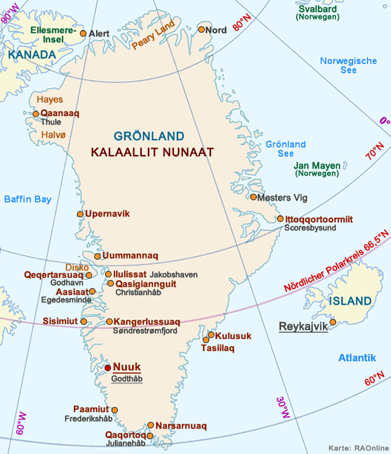
Langjähriger Grenzkonflikt in der Nares-Strasse beendet
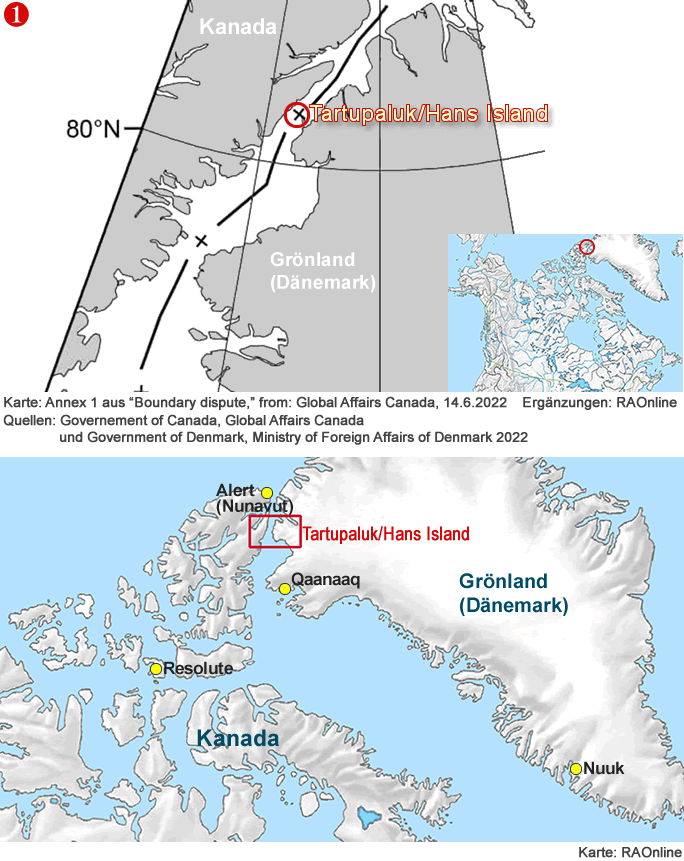
Nach jahrzehntelangen Unstimmigkeit über den Grenzverlauf auf der Insel Tartupaluk (grönländisch) / Hans Island (englisch) und deren unmittelbar angrenzenden Meeresgebieten haben Kanada und Dänemark im Juni 2022 in einem Abkommen u.a. den Grenzverlauf auf der Lincolnsee und Labradorsee und die Grenze auf der Insel Tartupaluk/Hans Island.
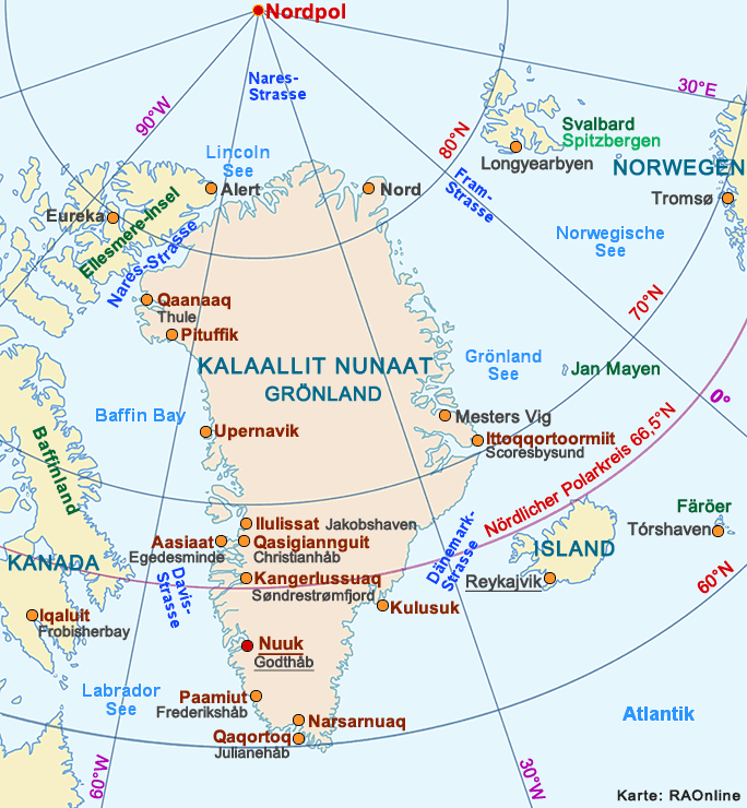
Die etwas über 1,2 km lange und 1,0 km breite vegetationslose, unbewohnte Felseninsel befindet sich im Kennedy-Kanal in der Nares-Meeresstrasse zwischen Knud Rasmussen Land (Kalaallit Nunaat = Grönland) im Osten und der kanadischen Insel Ellesmere im Westen. Die Inselfläche beträgt etwa 1,2 km2. Auf der Insel leben keine Wildtiere. Der höchste Punkt liegt auf 183 m über dem Meeresspiegel. Das Meer ist im Kennedy-Kanal in der Regel das ganze Jahr hindurch mit Meereis (Meereis 2022) bedeckt.
 |
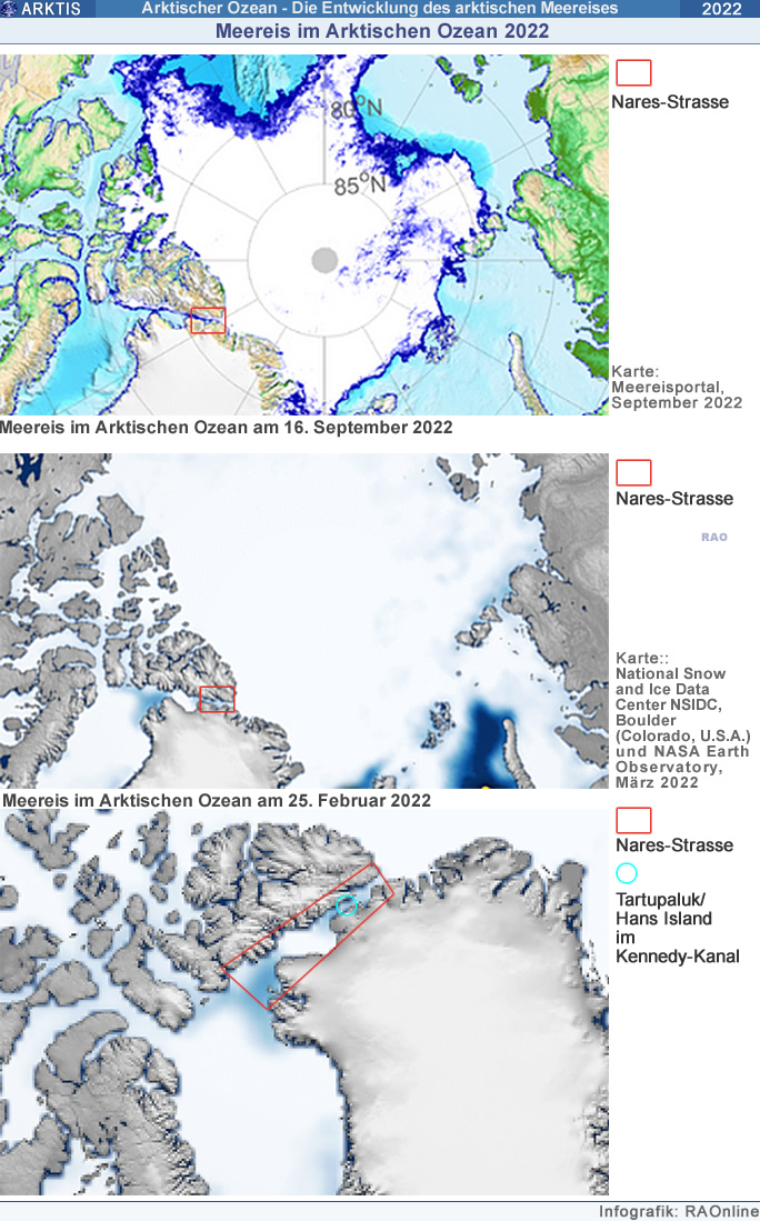
Der Klimawandel hat allerdings im Bereich der Inseln Crozier, Franklin und Tartupaluk zu sichtbaren Veränderungen bei der Meereisbedeckung im Kennedy-Kanal geführt. Satellitenaufnahmen über dieses Gebiet, welche in den letzten Jahren veröffentlicht wurden, zeigen eine deutlich Abnahme der Meereiskonzentration in den Monaten des Nordsommers. Während vor der Jahrhundertwende die Inseln im Kennedy-Kanal bei Bedarf das ganze Jahrhindurch über Schnee und Eis zu Fuss oder mit Hundeschlitten erreicht werden konnten, ist abzusehen, dass vor allem im Juli und im August die Meereisdecke durch Wärmeeinfluss derat ausgedünnt wird, dass ein Inselzugang zu Fuss nicht mehr möglich sein wird.
 |
Der Name Hans-Insel stammt von einem grönländischen Jäger ab, welcher sich im 19. Jahrhundert den dänischen Vornamen Hans Hendrik zulegte.
Die Insel besitzt für die lokale Bevölkerung in beiden Ländern eine grosse symbolische, traditionelle sowie historische Bedeutung. Eine einheimische Bevölkerungsgruppe, Inuit genannt, lebt in den Regionen von Avanersuaq, (Kalaallit Nunaat = Grönland) weiter südlich sowie um Nunavut (Alert) in Kanada.
Das neue am 14. Juni 2022 in Ottawa (Kanada) von den Aussenministern Mélanie Joly (Kanada) und Jeppe Kofod (Dänemark) sowie dem Premierminister von Grönland Múte B. Egede unterzeichnete Abkommen regelt die Seegrenzen innerhalb der 200-Meilen-Zone zwischen Kananda und Kalaallit Nunaat/Grönland (die Lincolnsee eingeschlossen) sowie den Grenzverlauf der Meeresgebiete über dem Kontinentalsockel (Festlandsockel) ausserhalb der 200-Meilen-Zone in der Labradorsee.
Das Abkommen, welches in Zusammenarbeit mit der lokalen einheimischen Bevölkerung in beiden Ländern ausgearbeit wurde, gewährt den Einheimischen freien Zugang zur Insel Tartupaluk/Hans Island und die uneingeschränkte Bewegungsfreiheit auf der Insel. Die Inuit dürfen im Bereich der Insel fischen und jagen sowie im Zusammenhang mir ihrer Kultur und Geschichte stehende Aktivitäten ausüben.
Bereits 1973 haben Kanada und Dänemark einen Vertrag unterzeichnet, welche den Grenzverlauf zwischen beiden Ländern regelte. Die Grenze in der Lincolnsee wurde allerdings im diesem Vertragswerk ausgespart. Dieser Umstand führte in der Vergangenheit zu Zwistigkeiten und kleineren Provokationen zwischen beiden Staaten. Ein 2012 ausgearbeitetes Dokument über den Grenzverlauf in der Lincolnsee wurde nie vertragsreif.
| Text: RAOnline |
| Quellen: Aussenministerien von Kanada und Dänemark 2022 |
 |
 |
 |
 |
 |
Internationales Seerecht: 12-Meilen-Zone und 200 Meilen-Zone
Die 200-Meilen-Zone (200 Seemeilen sm = 370,4 km wobei 1 Seemeile sm = 1'853 m) ist ein Seegebiet, welches durch eine Grenzlinie in einer Entfernung von 200 Meilen vor der Küste eines Staates begrenzt wird. Der an die 200-Meilen-Zone anstossende Küstenstaat darf in diesem Gebiet seine wirtschaftlichen Hoheitsrechte wie den Fischfang, die Forschung, den Naturschutz, den Rohstoffabbau, die Energieerzeugung usw. wahrnehmen. Der Küstenstaat darf die Zone als seine Wirtschaftszone mit begrenzten souveränen Rechten nutzen. Diese Rechte wurden im Seerechtsübereinkommen (SRÜ) von 1982 der Vereinten Nationen UNO festgelegt. Es gibt Staaten, welche das SRÜ nicht unterzeichnet haben. Dazu gehören u.a. die Länder Algerien, Äthiopien, Kambodscha, Kolumbien, Nordkorea, die U.S.A. und die Türkei.
Für das Seerechtsabkommen werden die Entfernungen in Seemeilenab einer Basislinie vor der Küste gemessen. Die einzelnen Staaten legen diese Linie selbst fest. In der Regel folgt die Basislinie der Wasserlinie bei Niedrigwasser (siehe: Gezeiten).
Nichtküstenanrainerstaaten haben lediglich das Recht der Hohen See. Sie dürfen das Gebiet mit ihren Transportmitteln wie Schiffen oder Flugzeuge zu Wasser oder in der Luft nutzen. Auch das Verlegen von Seekabeln und Seepipelines ist ihnen innerhalb der 200 Meilen-Zone gestattet.
In der 12-Meilen-Zone (12-Meilen = 22,2 km) darf ein Küstenstaat seine volle Souveränität ausüben. Die Meeresgebiete in dieser Zone gelten als seine Hoheits- oder Territorialgewässer. In diesem Gebiet gelten die entsprechend nationalen Rechte und Interessen, welche von den Küstenwachen und der Marine der jeweiligen Staaten überwacht und durchgesetzt werden.
Ausserhalb der 200 Meilen-Zone herrscht vertragsgemäss ein weitgehend rechtsfreier Raum. Auf dem Festlandsockel dürfen Küstenstaaten, wenn sie die geologischen Struktur des Meeresbodens vor der Küste (Festlandsockel) belegen bzw. beweisen können, bis maximal zur 350 Seemeilen-Grenze (350 sm = 649 km) ihr wirtschaftliches Interessensgebiet ( Bsp. Rohstoffförderung oder Fischerei) ausdehnen.
| Text: RAOnline |
| Quelle: Umwelt Bundesamt UBA (www.umweltbundesamt.de): Seerechtsü̈bereinkommen der Vereinten Nationen |
 |
 |
| Boundary dispute |
Canada and the Kingdom of Denmark, together with Greenland, reach historic agreement on longstanding boundary disputes
Today, Mélanie Joly, Minister of Foreign Affairs of Canada and Jeppe Kofod, Minister for Foreign Affairs of Denmark, along with Múte B. Egede, Prime Minister of Greenland, signed an agreement in Ottawa resolving outstanding boundary issues over Tartupaluk/Hans Island, the maritime boundary on the continental shelf within 200 nautical miles, including Lincoln Sea, and the continental shelf beyond 200 nautical miles in Labrador Sea.
Inuit of Nunavut and Kalaallit Nunaat/Greenland were consulted during the negotiations of this agreement. It maintains the traditional, symbolic and historic significance of Tartupaluk/Hans Island both to Inuit in Kalaallit Nunaat, in particular in Avanersuaq, and to Inuit in Nunavut, and will ensure continued access to and freedom of movement on the entirety of the island.
This agreement is a significant historic milestone in the relationship between friends and neighbours and is the culmination of years of discussions. The efforts deployed to reach this outcome demonstrate their leadership in the region and commitment to resolve disputes peacefully and in accordance with international law.
The land boundary on Tartupaluk / Hans Island reflects the strong historic and cultural relations between communities in Canada and Greenland. It paves the way for stronger cooperation and the establishment of an even closer partnership between them.
Quotes
"Nunavut is excited to learn about the new changes to our territory's boundaries and view this agreement as a benefit to Inuit and local communities. Our government is also encouraged to see that the agreement calls for continued access to and freedom of movement on the entirety of Tartupaluk island, including for hunting, fishing and other related cultural, traditional, historic and future activities for the Inuit of Nunavut and Kalaallit Nunaat."
- P.J. Akeeagok, Premier of Nunavut
"I am pleased to be part of the formal ceremony resolving boundary issues between Canada and Greenland concerning Tartupaluk/Hans Island. For Inuit, our lands, waters and ice form a singular homeland that we used, crossed and inhabited freely before formal boundaries were created by political jurisdictions. Our use of these areas underlie claims to sovereignty by nation states. It is an honour to join Inuit leadership and government representatives on this historic occasion."
- Natan Obed, President of Inuit Tapiriit Kanatami
"Today's signing ceremony marks a significant boundary agreement between Canada and Denmark for the island known by Inuit as Tartupaluk. Canada and Denmark share a rich and cooperative history, and it is fitting, and only a matter of time, that an equitable solution like this was reached, based on both practicality and compromise. We will continue our work with Inuit partners to ensure that all agreements are responsive to the needs of Inuit and Arctic residents."
- Daniel Vandal, Minister of Northern Affairs
"The Government of Newfoundland and Labrador welcomes the resolution of outstanding boundary issues in the waters between Canada and Greenland. As leaders in the Arctic region, the Federal Government and Denmark have ably demonstrated that neighbouring jurisdictions can participate in respectful negotiations and reach agreement on a forward-looking approach that aligns with international law."
- Andrew Furey, Premier of Newfoundland and Labrador
Background
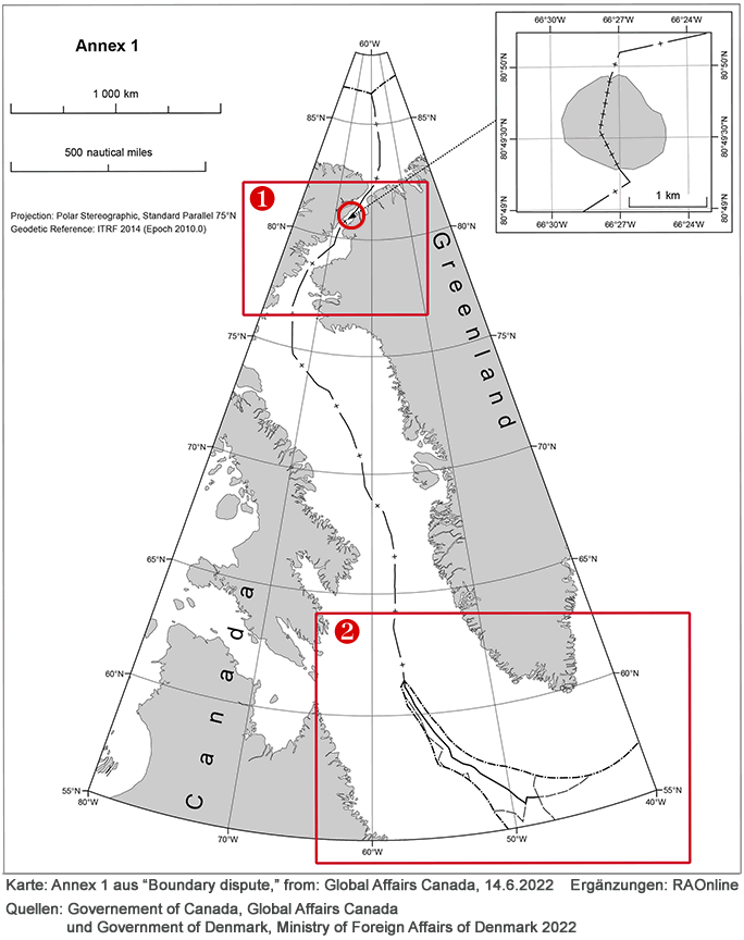
The new agreement between Canada and the Kingdom of Denmark, together with Greenland, resolves the long-standing dispute over sovereignty of Tartupaluk/Hans Island by creating a land boundary. It also modernizes the 1973 boundary within 200 nautical miles and establishes the maritime boundary in the Lincoln Sea. It further establishes a boundary on the continental shelf beyond 200 nautical miles in the Labrador Sea. See the map above.
The maritime boundary within 200 nautical miles, including the Lincoln Sea
In 1973, Canada and the Kingdom of Denmark signed a treaty that established a dividing line in the area between Greenland and Canada as far as, but not including, the Lincoln Sea.
In 2012, a tentative agreement on the maritime boundary in the Lincoln Sea was announced but not finalized. The delimitation line completes the process of technical adjustments to the coordinates of the existing boundary from 1973.
The present agreement incorporates the tentative agreement from 2012 and establishes a modernized single maritime boundary within 200 nautical miles from the Lincoln Sea in the north to the Labrador Sea in the south, which is almost 3,000 km.
Tartupaluk/Hans Island
The island known as Tartupaluk in Greenlandic and Hans Island in English is situated in the Kennedy Channel of Nares Strait between Greenland and Canada. The island is approximately 1.2 km² and is uninhabited and without vegetation or wildlife. However, the island has a traditional, symbolic and historic significance to the local population.
The land boundary on the island follows the natural ravine that runs the length of the island, generally in a direction from north to south.
Continued access to and freedom of movement on the entire island for Inuit and local people living in Avanersuaq, Kalaallit Nunaat, and in Nunavut (Alert), Canada, including for hunting, fishing and other related cultural, traditional, historic and future activities, will be maintained. A practical and workable border-implementation regime will be established for all visitors.
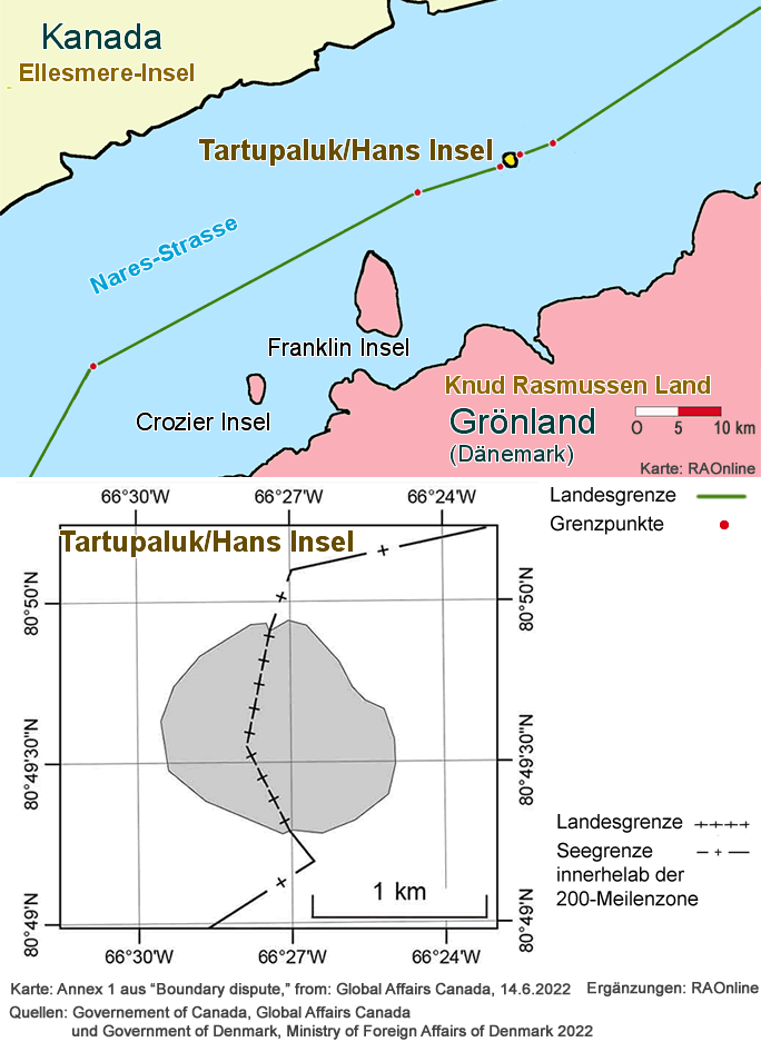
Labrador Sea
Canada filed a submission to the Commission on the Limits of the Continental Shelf (CLSC) regarding the outer limits of the continental shelf beyond 200 nautical miles in the Labrador Sea in 2013. The Kingdom of Denmark, together with Greenland, filed its own submission to the CLCS for the same area in 2012.
The submissions revealed an overlapping area of continental shelf, which is a normal part of the scientific process under the United Nations Convention on the Law of the Sea (UNCLOS) to delineate the outer limits of the continental shelf. The agreement establishes a binding boundary line in the overlapping area, which represents an equitable solution consistent with article 83 of UNCLOS.
The map above is for illustrative purposes only.
Map showing land boundary for Tartupaluk/Hans Island and maritime boundary within 200 nautical miles, including the Lincoln Sea.
| Source: Text Government of Canada, Global Affairs Canada, June 14, 2022 |
| Source: Text Ministry of Foreign Affairs of Denmark, June 14, 2022 |
 |
|
 |
|
|
| Links |
| Externe Links |
|
|
|
 |
| RAOnline Antarktis & Arktis Startseite |
|
|
|