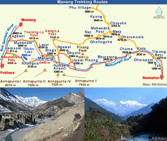
Nepal information
back
end
Trekkings
Nepal Trekkings
Manang
Upper Manang Trek
Annapurna Conservation Area Project
Nepal Information
Mustang Trekking
Thorong La
Manang
Manang Valley

Manang district can be reached in a five-day walk from the nearest road-head in Besisahar.

A major stop on the Annapurna circuit, Manang has much to offer the intrepid adventurer, climbers, the cultural and religious tourist.

The government has opened a number of new peaks in Manang and new destinations like Nar and Phu, the northernmost outposts of the district bordering Tibet are added attractions.

Annapurna Region
Neigbouring Region: Upper Mustang
Upper Mustang is the restricted northern part of Nepal's Mustang District which consists of seven Village Development Committees VDC (Nepal's smallest democratic units) with 31 settlements. The restricted area includes the historic kingdom of Lo Tsho Dhun, which translates as 'seven districts of Lo' in the local Tibetan dialect. Tibetan dialects prevail here too. And the ancient walled city of Lo Manthang is the most isolated and unexplored corner of the Himalayas. About 1100 Lobas (people of Lo), live in the 180 mud houses of the walled city and they observe a form of caste hierarchy.
External link
Special Link Manang Muktinath
Mustang & Lo Manthang
Thorong La

top

Upper Manang Treks: Nar and Phu
Annapurna South

The government has opened a number of peaks in Manang anddestinations like Nar and Phu, the northernmost outposts of the district bordering Tibet are added attractions. A trekking destination is Nar-Phu, a hitherto restricted region in the remote Upper Manang valley that is home to just 850 inhabitants. Only a certain number of tourists are allowed at a given time. The region boasts of original Tibetan culture and you need to obtain a special permit to travel there. The more challenging treks are to Kang La Pass, 5,322 metres above sea level and Thorong-La, 5,416 metres.

The Nar-Phu Valleys are located above the tree line on the upper limits of cultivation, in the very north of Manang district. It takes us five hours to reach the Kang-La Pass (5100 m) that links Nar with Manang and three other Bhotia villages in the Nyeshang Valley lower down. Nar has a population of some 300 villagers who depend on livestock for their living.

Day 1
Chame (or Koto)
Duration: 4 - 5 hours
Trail: downhill

Day 2
Chame (or Koto) to Metha (or Dharamsala)
Duration: 4 - 5 hours
Trail: along river, uphill before Metha

Day 3
Metha (or Dharamsala) to Kyang
Duration: 4 - 5 hours
Trail: undulating

Day 4
Kyang to Phu Village
Duration: 4 - 5 hours
Trail: rugged, undulating, along river

Day 5
Phu Village to Check
Duration: 4 hours
Trail: dry, rugged, undulating

Day 6
Check to Nar
Duration: 4 - 5 hours
Trail: uphill and then even

Day 7
Nar to Mira Point after crossing Kangla Pass (5100 m)
Duration: 5 - 6 hours
Trail: Even and then steep uphill

Day 8
Mira Point to Manang Village
Duration: 5 - 6 hours
Trail: steep downhill

Attraction: Nar and Phu En route: Gamsundu Max Elevation: 5100 m
Mustang & Lo Manthang
Thorong La
Annapurna II
more information on Nepal
The Himalayas around Pokhara
Nepal's Topography
Nepal's Foot Hills
Annapurna Conservation Area Project
Round Annapurna Trek
Upper Manang Trek
Annapurna Trek Photo Gallery
Cross-section of Nepal
Mustang & Lo Manthang
Upper Manang Trekking
Thorong La
Annapurna Trek Photo Gallery
back