| Bhutan
- Ethnic Groups & People |
| Brokpas of Merak - Sakten (Sakteng) |
 |
Bhutan People Merak - Sakten |
|
|
 |
 |
 The
geographical location The
geographical location |
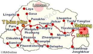
| Located
in the two eastern most geogs in Trashigang dzongkhag and wedged between
the glacial valleys of Greater Himalayas, and bordering the Indian state
of Arunachal Pradesh in the North and North East lies Merak and Sakteng.
At about 3000 m above sea level-the lower limit of glaciation in Bhutan
- even during the summer months the Brokpa habitat is a glacially sculptured
landscape. |
|
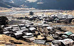
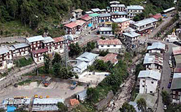
While Merak is an upland valley along Nyera Ama Chhu Sakteng is located on the
lower valley along Gamri Chhu. According to the demographic of the
geogs, Merak has about 213 households with a population of 1,908 while
Sakteng 330 with about 2,126 residents. Together they form 0.12 percent
of the total population of the country. Gender ratios in the two geogs
vary from 1141.4 males per thousand females in Merak to 1051 males in Sakten.
"The gender ratio of both the gewogs are higher than that of the country
because of nature of Brokpa economy which requires more manpower," said
the study.
|
Sakteng Path
|

|
 |
| It
is a day and a half walk over hills and ridges, following the Sakten chhu
(river), which has to be crossed several times and through the villages
of Joenkhar and Thrakthi under Sakten dungkhag before reaching Sakten.
People
walking to Sakten normally start at six in the morning from Trashigang,
carrying their own rations to cook meals along the way. |
|
Saktenpaswho come with their caravan of horses and yaks to carry their food stock
take three days to reach home as the animals find it difficult to climb
the steep rock-strewn path.
"Time
and again we have to get the loads off the animals and feed them lest they
cannot continue the journey the next day," said Dorji a Saktenpa who frequents
Trashigang town.
The
journey uphill begins at Phongmey which is about 33 kilometres from Trashigang
town and the end of the road point. From Phongmey the hike to Joenkhar is a four hour walk through dense forest and narrow jagged path.
It
is usually the shopkeepers who regularly travel the route to stock up their
food reserves like cases of beer and whisky, salt, sugar and kerosene.
 |
Although
most official visitors stop for the night at Joenkhar, the first village
on the way, the Saktenpas prefer moving further up and spending the night
in open air where their horses and yaks can graze freely in the forest.
The
Saktenpas normally make a bonfire and sleep around it. They cover their
back with a yak woollen blanket while their front faces the fire and change
their positions when their back feels cold. |
|
"One has to again light up
the fire when it goes off," said Dorji Wangdi.
It
is another 10 hours walk the next day to Sakten from Joenkhar and travellers
start off early when the path is covered with frost and ice. The climb
gets steeper and the weather colder as one moves further up.
After
five hours of steep climb Thrakthi village is the next stop, the mid-point
to Sakten from Joenkhar. Thrakthi's only shop has packet noodles, beer
and beverages for sale. The Saktenpas, however, prepare their own meal;
rice and spinach and dry chilli curry.
 |
| From Thrakthi it is another five hour walk to Sakten. According to the Sakten
Lam, Norbu Wangdi, the route to Sakten had been shortened and made easier
for travellers after that the government cleared the new route. "The earlier
route was steeper than this and most Sakten people found it difficult to
travel," said the Sakten Lam. "Now we can reach Sakten an hour earlier." |
|
| Contributed
by Samten Wangchuk, Kuensel |
 |
| more
information |
 |
|


