|
Bhutan History |
|
|
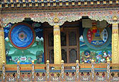
Bhutan Information |
|
|
 |
|
How
Europe heard about Bhutan
|
When
did Bhutan first appear on a western map? When did Europe first become
aware of Bhutan's existence?
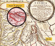 |
| The 1683 map by Cantelli which sparked Dr Gandolfo's investigation |
| With these questions in mind, Dr Romolo Gandolfo,
an Italian history lecturer and newspaper editor now based in Greece, decided
to start investigating the issue by paying a visit to the largest map shop
in London two years ago.
After
hours of digging in the shop's drawers, he suddenly came across a map of
Northern India dated 1683 in which a 'Regno di Boutan' (kingdom of Boutan)
stood where one would expect to find today's kingdom of Bhutan. |
|
Presenting
a paper on Bhutan and Tibet in European cartography: 1582-1800 at the international
seminar on Bhutan studies, Dr. Gandolfo said that many elements in this
map, drawn by Italian geographer, Giacomo Cantelli da Vignola, baffled
him. For example, Nepal appeared not once, but twice, and in quite distant
places. Boutan was plotted north of, rather than south of, Mount Caucasus,
as the Himalaya was known in Europe during the 17th century. Besides, the
only Europeans known to have visited Bhutan by that time (the Jesuit fathers
Cacella and Cabral, in 1627) had written that the country was variously
called Cambirasi, 'the first Kingdom of Potente', or Mon. If so, where
did the Italian cartographer get the name Boutan from?
Dr
Gandolfo points out that Cantelli's main source was The Six Voyages into
Persia and the East Indies, a best-selling travel book written by Jean
Baptiste Tavernier, one of the richest and most famous European merchants
in Asia. In this book, first published in French in 1676, Tavernier has
a section titled "The Kingdom of Boutan"in which he explains that this
mysterious country was very large and distant from India; that it is located
beyond the mountains of the Raja of Nupal (Nepal); and that it was frequented
by rich merchants coming from places as far away as the Ottoman Empire
or the Baltic Sea. Tavernier then goes on to describe the 'King of Boutan',
saying that 'there is no king in the world who is more feared and more
respected by his subjects, and he is even worshipped by them.'
Anyone
familiar with the geography and the history of the Himalayan region in
the middle of the 17th century, argues Dr Gandolfo, should be able to recognise
that Tavernier is here describing Tibet and the Dalai Lama, rather than
Bhutan and the Zhabdrung. Clearly, the Kingdom of Boutan that appears
in Cantelli's map is, in reality, Tibet. In other words, Boutan was
an alias, a synonym, for the whole of Tibet, a name in use across Northern
India, from Kashmir to Bengal. Unfortunately Tavernier never mentions Lhasa
as the capital, thus making Cantelli and other European map makers unclear.
 |
| Names
similar to Boutan (Bottan, Bottanter) had begun to appear in Europe
as early as the 1580s in reference to a large country north of India,
where a pious and light-skinned mountain people was said to live. |
|
A description of this newly discovered nation (the 'Bottanthis') appeared
in a book and a map published in Italy in 1597. Many Europeans thought
that the Botthantis might be the lost Christian nation of Prester John,
a mythical priest/king who, according to medieval lore, lived somewhere
in the heart of Central Asia. It was the hope of reestablishing a contact
with this forgotten Christian people that drove a score of Jesuit fathers
into Tibet and present-day Bhutan in the 1620s.
From 1700
till the 1770s the term Boutan appeared on several important European
maps of Asia as an alias for the whole of Tibet (or of the 'Kingdom of
Lhasa'). The most important and detailed of these maps (published in 1733)
is even titled "General Map of Thibet or Bout-tan". Despite the fact that,
during the first half of the 18th century, a group of Italian missionaries
resided in Lhasa and wrote many reports and letters back to Europe in which
they clearly mentioned present-day Bhutan under several native names, these
documents apparently disappeared in the archives and never reached the
map makers. Or, if they did, they were discarded for lack of reliable geographical
details.
Until
the 1770s, present-day Bhutan failed to appear on European printed maps.
It did appear, however, under the name of 'Broukpa', in a beautiful sketch
map drawn around 1730 by Samuel van Putte, a Dutch "explorer"of the early
18th century who travelled alone across all regions of Tibet (but not into
present-day Bhutan). Showing a reproduction of the map, Dr Gandolfo sadly
remarks that the original, kept in a Dutch museum, had been destroyed during
WWII in a bombing.
So,
when did Druk-Yul (also known as Brukpa, Lho Mon) get its present
western name of Bhutan? Only in 1775, says Gandolfo, after Bogle's
trade mission to the Deb Raja and the Panchen Lama in Tashilhunpo. In his
instructions to Bogle, in 1774, Warren Hastings, the Governor General of
the East India Company, still refers to Tibet as Boutan. And Bogle initially
uses the two terms interchangeably.
It
was only after he was detained for four months in Thimphu valley by the
Deb Raja in the rainy summer of 1774 that Bogle developed a clear appreciation
of the specific features - political, cultural and religious- of Bhutan.
Upon crossing the border near Phari, Bogle appears to realise that he was
now in a different country. His long and friendly stay at the Panchen Lama's
court definitively convinced him that he had visited two distinct countries.
When he eventually returned to Bengal, he wrote a final report to the Governer
General in which he formally proposed "to distinguish"the Deb Raja's country
by the name of Boutan and to keep the name 'Tibet' for the large country
on the plateau.
James
Rennell, the first Surveyor General of the East India Company, who had
already plotted part of the Duars, immediately followed his suggestions.
It was Rennell who first anglicised the French spelling Boutan into Bootan.
And it was he who, in his maps, detached Bootan from Tibet, bringing it
down south of the main Himalayan range.
If
Bogle 'discovered and named' Bhutan, concludes Dr Gandolfo, it was
Rennell who, with his numerous and authoritative maps, published between 1780
and 1800, made Europe aware of the existence of this new country. After
that Bhutan was no longer, in Europe's eyes, a be-yul-a hidden country.
| Information on Bhutan |
 |
|