|
Nepal Information |
|
|
|
| Nepal,
a federal and democratic Republic, lies between 80°4' and 88°12'
east longitude and 26°22' and 30°27' north latitude. It is bounded
on the north by the Tibet Autonomous Region of the People's Republic of
China; on the east by Sikkim and West Bengal of the Indian Union, on the
south by Indian states of Bihar and Uttar Pradesh and on the west by India's
new Himalaya State Uttaranchal. |
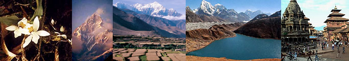
Geographically
divided into mountains ("parbat"), hills ("pahad") and lowland
plains ("Terai"), the Himalayan nation is administratively divided
into five development regions - far west, mid-west, west, central and east.
The climate in the Terai region is particularly hot and humid. Compared
with the mountain and hill areas, the Terai is the most populated.
| The
country can be divided into three main geographical regions |
 |
| The
Terai (up to 200 m) |
 |
 |
The
low-land Terai region which has a width of about 26 to 32 kilometres and
a altitude of maximum 305 meters occupies about 17% of the total land area.
The Terai constitutes the northern belt of the Gangatic Plains.The
Terai is Nepal's most densely populated region. It is the country's most
fertile stretch of land. The Terai has more than one million hectares of
paddy fields. |
The
Terai was almost entirely forested and was a zone where malaria was endemic.
Today less than 50% of the forests now remains. Kechanakawal (Jhapa district)
is the lowest point of the country with an altitude of 70 meters above
sea level.
| The
Middle Zone (1,500 m to 6,000 m) |
|
The
region of the Himalayan foothills forms a buffer zone between the Gangatic
Plains to the south and the High Himalaya to the north. Immediately north
of the Terai are the forested Churia Hills, whose altitude varies
from 610 m to 1,524 m. The Churia Hill belt has a lot of river valleys which
can be highly fertile.
 |
To
the north of the Churia Hills is the Mahabharat Lekh that soars
up to 4877 m. Peak elevations increase to heights of up to 2,600 m. The
slopes are widely forested, sometimes with evergreen oaks and firs. In
areas of higher rainfalls the rhododendron trees flourish in springtime. |
The
broader Pahar zone extends from the Mahabharat Lekh to High Himalayas.
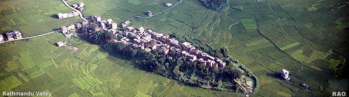
This region includes both the kathmandu and the Pokhara valleys. The elevation
range from 1,000 m above sea level to 4,000 m and higher. The many river
valleys allow often intensive cultivation of land. The slopes often also
are cultivated with intricate terraces.
At
lower elevations the forest are characteristically sub-tropical. With increasing
in altitude they become moist temperate, consisting largely of pine, spruce,
cedars, firs and the attractive rhododendrons whose white, purple and red
flowers blossoms from late March to early May. The Mountain Region accounts
for about 45% of a total land area.
| The
High Himalaya (Peaks over 6,000 m) |
|
 |
The
altitude of thisregion ranges between4,800 m and 8850 m.
It includes 8 of the existing 14 summits in the world which exceed an altitude
of 8,000 m.A series of massifs are separated from one another by
deep gorges: Separating Dhaulagiri from the Annapurnas, the 6,000 m deep
Kali Gandaki is the deepest in the world. |
|