|
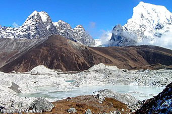
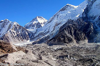
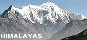
Nepal Himalayas Glaciers |
|
Nepal Information |
|
|
 |
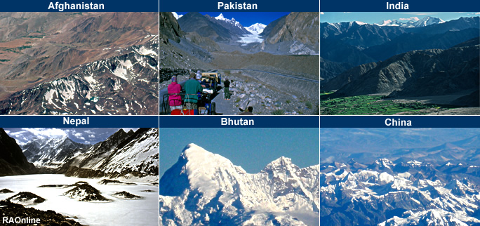
| Hindu Kush-Himalayan (HKH) region
|

|
|
New Reports Identify Impacts of Climate Change on World's Highest Mountains
|
|
|
Findings from the most comprehensive assessment to date on climate change, snow and glacier melt in Asia's mountainous Hindu Kush-Himalayan (HKH) region-site of Mount Everest and many of the world's tallest peaks-highlight the region's extreme vulnerability to climate change, as rising temperatures disturb the balance of snow, ice and water, threatening millions of mountain people and 1.3 billion people living downstream in Asia's major river basins.
The findings, published in three reports by the Kathmandu-based International Centre for Integrated Mountain Development (ICIMOD), were released today during Mountain Day, a convening of mountain experts, policy makers, and climate change negotiators on the sidelines of UN climate talks.
"These reports provide a new baseline and location-specific information for understanding climate change in one of the most vulnerable ecosytems in the world," said Dr Rajendra Pachauri, Chair of the Intergovernmental Panel on Climate Change (IPCC). "They substantially deepen our understanding of this region - and of all mountain systems - while also pointing to the knowledge gaps yet to be filled and actions that must be taken to deal with the challenge of climate change globally and to minimise the risks from impacts locally."
The three reports published by ICIMOD provide the most up-to-date compilation of information on the current status of climate change in the HKH region and the first authoritative data on the number and extent of glaciers and the patterns of snowfall in the world's most mountainous region.
"The Hindu Kush-Himalayan region is like a gentle giant. While physically imposing, it is one of the most ecologically sensitive areas in the world," said David Molden, director general of ICIMOD. "We must meet the intensity of climate change in these mountains with an equal intensity of will to mitigate and to adapt to the impacts."
The region offers livelihoods to the 210 million people living there and indirectly provides goods and services to the 1.3 billion people living in river basins downstream who benefit from food and energy. Rich in biodiversity, the region is home to some 25,000 plant and animal species, and contains a larger diversity of forest types than the Amazon. Yet despite an abundance of natural resources in the region, poverty is rife. HKH countries account for 15 percent of the world's total migration.
Valuable new data on glaciers and snow
The HKH region, home to 30 percent of the world's glaciers, has been called the "Third Pole." But there are scant data on these glaciers. One of the reports, The Status of Glaciers in the Hindu Kush-Himalayan Region-presenting findings of a three-year Sweden-funded research project led by ICIMOD-begins to fill in the important data gaps. Using remote sensing studies, the project was able to tally the number of glaciers in the region-more than 54,000-and measure the area covered, 60,000 km.
Of these 54,000 glaciers, however, only ten have been studied regularly to determine the net loss or gain of ice and snow (called the mass balance). That handful of studies shows a loss of mass balance, with the rate of loss roughly doubling between 1980 and 2000 and 1996 and 2005. In the Everest area, the data show a marked acceleration in the loss of glacial mass between 2002 and 2005.
Glaciers appear to be shrinking in both the central and eastern Himalayas. Country-specific studies have found that depletion of glacial area over the past 30 years was 22 percent in Bhutan and 21 percent in Nepal.
The clean glaciers of the Tibetan plateau are retreating at a faster rate than the glaciers of the rugged central Himalayas, which have higher debris cover; debris creates an insulating effect, slowing melting.
Although field verification and additional data collection will be needed before firmer conclusions about glacier retreat can be drawn, the data represent a significant step in bridging the knowledge gap on climate change in the HKH. "Up until now, there has been complete uncertainty on the numbers and area of glaciers and the present status of their environmental conditions in the region. This research give us a baseline from which to measure the potential impact of climate change in the region and to develop options for mitigating the impact of dynamic changes the region is expecting in the coming years," said Basanta Shrestha from ICIMOD.
A second report, Snow-Cover Mapping and Monitoring in the Hindu Kush-Himalayas, documents the first comprehensive status report of snow cover in the region, drawn from a regional monitoring scheme. However, there was an indication of an overall decrease in snow cover over the decade in the central HKH region and overall, and a slight increase in the western and eastern parts of the region.
The HKH region's glaciers and snow breathe life into the regional monsoon system and feed the headwaters of 10 major river systems that stretch across eight Asian countries-Afghanistan, Bangladesh, Bhutan, China, India, Myanmar, Nepal and Pakistan.
Status of climate change in a vulnerable region
"The HKH region is one of the most ecologically sensitive and fragile areas in the world.
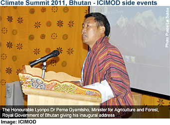 |
| The effects of climate change will likely become more evident here than perhaps any where else first-and with the greatest impact-since this ecosystem supports the livelihoods of more people than any other coherent ecosystem in the world," said the Hon. Lyonpo Dr. Pema Gyamtsho, Minister of Agriculture and Forests and also Minister In-charge of Environment of Bhutan. |
|
"Meeting this challenge will require increased regional cooperation between governments and other actors. This research, which involved eight countries in the HKH region, represents the kind of cooperation needed to meet the climate challenge."
The third report, Climate Change in the Hindu Kush-Himalayas: The State of Current Knowledge, considers the mass of data and published studies in three major areas: climate and hydrology; biodiversity and ecosystems; and atmospheric changes. It also points out the limits of current data and the short time frame of most records (few extending more than 50 years). In addition, climate-related studies in the region suffer from a lack of repeat studies, permanent plots, field validation, and peer review. Nonetheless, the report provides a snapshot of changes occurring in the HKH region.
The HKH region is one of the world's hotspots for global warming. The rise in temperature has been greater at higher altitudes and more pronounced during the cooler months than in the warmer months. This imbalance narrows the seasonal variation in temperature, potentially favoring some plant species over others and already having impacts on agriculture.
Warming across the region is greater than the global average of 0.74°C over the past 100 years. However, this change is not evenly distributed. It is most pronounced in higher altitude areas like the central Himalayas and the Tibetan Plateau. In Lhasa, for example, temperatures increased by 1.35°C between 1950 and 1980.
Impacts of warming and melting in the HKH
Two major land use systems in the region are changing. In mountain forests, tree lines and species are shifting to higher elevations, and species already living at the highest elevations may have nowhere to go. Meanwhile, the vast grasslands of the Tibetan Plateau are being steadily degraded.
Increases in glacial melting are projected to limit the natural water storage provided by expanses of snow and ice and to heighten the risk of glacial lake outburst floods. Mass losses from glaciers and accelerating reductions in snow cover are expected to ultimately reduce water supplies and hydropower potential. Changes in the seasonality of flows in river basins supplied by melt water from snow and ice are also predicted. Droughts will likely affect greater areas, and with dry spells there will need to be greater reliance on irrigation, even as water sources become more restricted, according to the authors. The risk of flooding is also increasing with increased variability of climate.
Agriculture is very sensitive to climate change, which can affect temperature, precipitation, length of growing season, the timing of climate events relative to crop development, and changes in atmospheric CO2 concentration. However, the report notes the difficulty of projecting the impact of climate change on agriculture, as it occurs along with many other drivers.
This compilation of information is a vital first step. "From here, greater focus needs to be put on providing people and governments with options for climate-resilient development," said Molden. "These include adaptation and mitigation measures such as reducing emissions from deforestation and forest degradation, water storage measures, and regional cooperation around policies for managing water for energy, agriculture and development."

|
| Source:
ICIMOD, International Centre for Integrated Mountain Development , December 2011 |
|
Hindu Kush-Himalayan (HKH) region
|
|
|
ICIMOD
The
International Centre for Integrated Mountain Development (ICIMOD) is an
independent 'Mountain Learning and Knowledge Centre' serving the eight
member countries of the Hindu-Kush-Himalayas - Afghanistan, Bangladesh,
Bhutan, China, India, Myanmar, Nepal and Pakistan - and the global mountain
community. ICIMOD is a non-political intergovernmental organisation which,
since 1983, has encouraged technical cooperation between governments in
the region and whose primary objective is to help promote the development
of environmentally sound mountain ecosystems and improve the living standards
of the mountain population. www.icimod.org
|
|
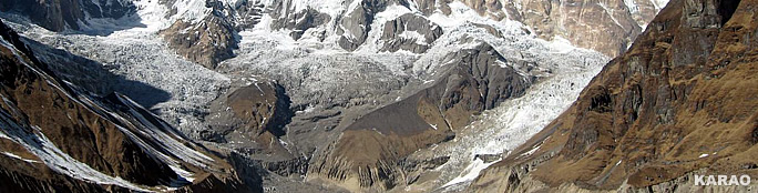
Glaciers
flowing down from Annapurna I |
top
|
Information
|
|
| Reports |
|
| Himalayas |
Snow, Ice, Glacier, Glacial Lakes and Floods Reports |
 |
|
Links |
|
|
 |
|
External
link |
 |
International
Centre for Integrated Mountain Development
ICIMOD |
|
 |
|